- +86-13267351235
- info@globalstourtravels.com
Located at the foot of Mount Yulei on the 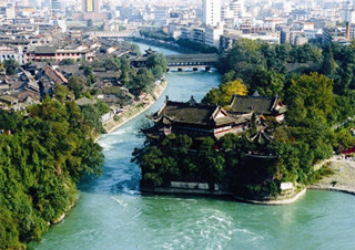 middle reaches of the Minjiang River, Dujiangyan Irrigation System is 45 kilometers away from Chengdu. It is the oldest and greatest irrigation System which still functions in the world.
• It is a national monument approved by the State Council in February 1982.
• It is inscribed on the List of World Cultural Heritage, ratified by UNESCO in December 2000.
• It is the oldest and greatest irrigation System which still functions in the world.
• It is the unique automatic irrigation System without a concrete dam in the world.
Dujiangyan Irrigation System, constructed by prefect Li Bing of Shu prefecture in 227 B. C. , is a historical monument of science and technology and a wonder of the world. The System has been playing the role of channeling water to the Chengdu Plain for over two millenniums, turning it into the Land of Abundance. Now the System is still irrigating an area of over 7, 000, 000 hectares.
According to historical records, Dujiangyan Dam was constructed during the Warring States Period over 2, 000 years ago by Li Bing (the prefect of the prefecture of Shu, present Chengdu region) and his son.
In ancient times, Chengdu Plain saw frequent floods during heavy rains and droughts in dry spells. To alleviate the sufferings, Li Bing decided to build a key irrigation project in Guanxian after he had surveyed the river and terrain there. He first built, along the middle course of the river, a long dike of sand and stone to divide the river into the inner branch channel and the outer branch channel, then cut a bottle-neck-like canal (now referred to as Baopingkou) through the jutting part of the Yulei Mountain on the river bank, and still then dug a water distribution network to divert the river water to irrigate the vast Chengdu Plain. The inner branch channel contains 60% of all the river water in rainy seasons while the outer one contains 60% of that in dry spells. As a result, Li Bing achieved his goal of dividing floods to alleviate sufferings.
To honor Li Bing and his son for their great exploits, later people built a 30-odd-metre-high shrine named Subduing Dragon near Baopingkou, enshrined in which is a statue of Li Bing. On a height behind the shrine stands the Viewing Wave Pavilion, where visitors can enjoy themselves by watching the scene of the towering Qingcheng (Green City) Mountain far away or listening to the splashes of the rushing river near below. Yulei Mountain offers another shrine named Erwang (Two Kings). Apart from two statues of Li Bing and his son, the shrine houses many precious cultural relics including articles of earth ware, chinaware and ironware from ancient times, as well as the inscriptions of guiding principles, three-character cannons and eight-character mottoes, all significant for controlling floods and composed by Li Bing.
The panorama of Dujiangyan Irrigation System comes into view as you ascend the tower located on Mount Yulei. The Minjiang River, roaring through the valleys of the rolling mountains, rushes down through the water conservancy System to the Chengdu Plain, which is crisscrossed by rippling rivers and canals. The front works of the System are a miraculous application of scientific principles. The marvelous design and the ancient Chinese ability to take advantage of Nature are so ingenious that some tourists today are still bewildered by this miracle. The application of scientific principles in the System and the benefits brought upon the Land of Abundance still causes many to gasp with admiration; the hydraulic experts claim that the life cycle of any conservation System built with today' s hi-tech methods would not survive more than 200 years, but Dujianyan has already survived more than 2, 200 years.
Dujiangyan is mainly made up of three major works. The raging torrent of the Minjiang River is separated into two streams at the bend by a dike shaped like a fish. The front segment of the dike is named "Yuzui" (Fish Mouth), the lower stretch of the dike, "Feishayan" (Sand-flying Spillway) and the final segment is Baopingkou (Bottle-neck Channel) , the water channel between Mount Yulei and Lidui (the Isolated Mound). The Fish Mouth was constructed to divide the water into the inner river as a canal and the outer river as a floodway. The Sand-flying Spillway functions as a spillover and serves as flood draining; and the Bottle-neck Channel diverts a due amount of water into the canal. The extraordinary coordination of the three major constructions contributes to the miracle of Dujiangyan Irrigation System.
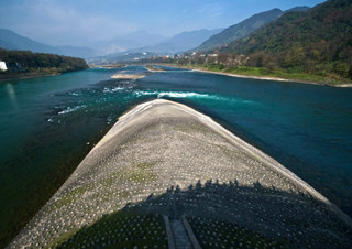
The Water-dividing Dike, aptly dubbed the Fish Mouth, works as the key section of the Dujiangyan Irrigation System. Standing on the bank of the Dike, you can observe that the surging Minjiang River is divided into the inner canal and the outer canal. Why was the Fish Mouth constructed there? What a role does play in the whole System? There is a saying; "Divide water by 40% and 60%; subdue flood and drought."This motto was carved on the cliff near the Erwang Temple(Temple of Two Kings).
The main function of the Fish Mouth is water diversion. Li Bing had the System built, based on the favorable terrain at the Hanjiaba FlaUand. The outer side of the riverbed is higher than the inner side of this section of the Minjiang River, where the river bends. To take advantage of the topography, 60% of the water along the lower side of the dike (Fish Mouth) flows into the inner canal so as to guarantee the irrigating water in spring when the farmers plough their fields. In the flood season, the flow volume increases rapidly and the water level is much higher. The bend of the river has much less restraint on the water torrent as it does in the dry season. In addition, the outer canal is wider than the inner canal. As a result, the Fish Mouth discharges 60% of the water to the outer canal and leaves only 40% of the water flowing through the inner canal, which prevents the flood from inundating the Chengdu plain. The effect of water division is summarized as a six-character motto; "Divide water by 40% and 60%; subdue flood and drought."
The Fish Mouth also has the function of releasing sand and pebbles carried by the torrent. It is strategically set at the end of the bend, which turns out to be an ideal location for both channeling water and sweeping away sand and pebbles. According to the principle of bend hydrodynamics, the clean water of the surface is inclined to flow into the inner canal along the convex side of the dike; the sand and pebbles tend to rush to the outer canal through the riverbed along the concave side of the dike. It is estimated that about 80% of the sand and pebbles are swept away into the outer canal while the inner canal is prevented from being silted up. People may wonder about the remaining 20% sludge and pebbles, and how to drain them? The Feishayan (Sand-flying Spillway) and Baopingkou (Bottle-neck Channel) are perfectly designed to solve this problem.
Feishayan or Sand-flying Spillway is the second major construction of the Dujiangyan Irrigation System for the purpose of spilling floodwater and sand into the inner canal. To understand how the Sand-flying Spillway operates, you may first compare it with Baopingkou or the Bottle-Neck Channel. The channel is an opening carved out of Mount Yulei, where a part of the mountain is cut off, thus creating a mound named Lidui (the Isolated Mound) and a 20-meter wide water inlet. Water flows into the Bottle-neck Channel through the 100-meter wide inner canal. When the river keeps its normal level, the water can pass smoothly through the Bottle-neck Channel. However, when the water level rises higher in the flood season, the water always overflows the bank and causes serious flooding unless it is diverted elsewhere. In an attempt to coordinate with the functions of Bottle-neck Channel, Li Bing demanded that the Sand-flying Spillway be built up, just 2.15 meters higher than the riverbed of the inner canal. As soon as the water level of the inner canal surpasses 2. 15 meters, the turbulent water will flow out of the Sand-flying Spillway. Therefore, the volume of water in the Bottle-neck Channel is maintained at a constant level, and the Chengdu plain is relieved from flooding and the proper irrigation is secured.
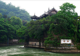
A key section of Dujiangyan Irrigation System, the well-designed Baopingkou or Bottleneck Channel, acts as a water inlet that controls the water volume which flows to the Chengdu Plain from the inner canal. Shaped like a bottleneck, the channel places rigid limits over the flow entering the irrigation network of the Chengdu plain. It is a small channel, 36 meters long, 18.8 meters high, 14. 3 meters wide at the bottom and 28. 9 meters wide at the top. As a key part of the System it plays a crucial role in controlling the flow in coordination with Sand-flying Spillway. The conservation data measured over the past decades reveals that the annual average discharge through Bottle-neck Channel is 254.6 cubic meters per second, and about 535. 6 cubic meters in the flood season. The data indicates that Bottle-neck Channel and Sand-flying Spillway play a key role in regulating the water automatically. The stable discharge of water proves essential for the automatic irrigation and beneficial to the daily life of the people. More importantly, it safeguards the Chengdu plain against drought and flood.
Not far away from the Sand-flying Spillway is the Lidui Park. Lidui was carved by Li Bing out of Mount Yulei, an opening through which the water passes. It was indeed a laborious task to cut the mountain of gravel and sedimentary rock more than 2, 000 years ago when gunpowder was not yet invented and ironware was primitive. However, Li Bing was wise and had an idea of "fire attack". He had the woods piled up on the rocks and then set them on fire. The surface of solid rocks was heated by the fire and then the laborers poured water onto it. After cutting off the split layer, they burned the next layer and repeated this process continually. Eight years later, a gap 20 meters wide, 40 meters high and 80 meters long was dug and separated from Lidui. Then, Bottle-neck Channel was successfully built up.
Located at the center of the inner canal, Lidui resists the brunt of the raging water, which results in a powerful reactive force. The water is stopped by Lidui, thus swirling at its foot. Consequently, the reactive force interacts with the active force of consecutively rushing waves, creating a thrashing circular force. The repeated revolving cycles are so strong that even boulders can be swept away from Sand-flying Spillway. The principle of bend hydrodynamics takes effect, and 15% of the sand in the inner canal is washed away. In the end, the water with only about 5% silt flows to the Chengdu plain.
The Dragon-taming Temple is built on the Isolated Mound, named after the legend " Erlang captures the evil dragon". In the 4th century (303—347) the Temple was originally built in memory of Fan Changsheng, the chieftain of the Heavenly Master Sect of Taoism at Mount Qingcheng. In the period of Five Dynasties and Ten States (907—960) , the title of " King of Grand Peace" and "King of Saint Spirit" was conferred upon Li Bing, during which time the temple was changed to the Temple of Master Li. Later on it was renamed as the Dragon-taming Temple according to the folk story that Li Bing and his son subdued an evil dragon.
After you climb 42-stair steps, you will find a stone tablet engraved with the Chinese characters ^i^(Li Did). An array of 11 tablets will also come into view. They are engraved with the incantations of Confucianism, Taoism and Buddhism, indicating that the magic powers of the three religions are mobilized to tame the river below. They are generally called Zhenshui Tablet (River-taming Tablet). However, the locals believe otherwise; They were erected to suppress the evil dragon underneath rather than the river, for the evil dragon would make troubles without the magic powers of Zhenshui Tablet.
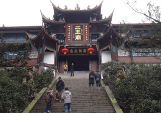
Located at the foot of Mount Yulei, the Erwang Temple was built in honor of the esteemed builders of Dujiangyan Irrigation System, Li Bing and his son. The temple was originally named Wangdi Shrine, a temple constructed to commemorate Du Yu, a king of the ancient Shu Kingdom. Later it was moved to Pixian County during the period of Southern and Northern Dynasties (420—589). Then the Temple was changed to the Chongde Temple (Temple of Noble Merits) to express the local people's admiration for the Li family. During the Song Dynasty (960— 1279), the title of "King" was conferred on Li Bing and his son in succession. Therefore, the Temple of Noble Merits was renamed the Temple of Two Kings. The present name of the Temple was not officially adopted until the Qing Dynasty (1644—1911). It distinguishes itself in five aspects; ( 1 ) It takes up little land-only covers an area of 10, 072 square meters. (2) The architectural density is as high as 60% . (3) Symmetry is not a prerequisite observed here, contrary to the basic style of ancient Chinese architecture. (4) The drop in elevation between the top and the lowest point of the temple is 63 meters. (5) It is imposing in scale, with a compact layout and a grand feast for the eyes of tourists.
The Hall of Li Bing is situated in a quadrangle. Opposite to it stands a wooden platform for performing Sichuan Opera. The opera was not staged for the common people but for Li Bing, who had been exalted as a deity of Sichuan. The temple fair is annually held within the temple on June 24th on the Chinese lunar calendar. The Ming and Qing Dynasties saw opera here every year on that day. People went up to the Temple to offer sacrifices to the deities and to pray for blessings. Bustling activities of all kinds accompanied this annual pilgrimage. The custom of going to the temple fair was revived in 1992.
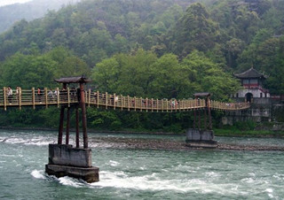
Not far away from the Temple of Two Kings, over the Minjiang River hangs the Anlan Cable Bridge. Anlan in Chinese refers to "slowing down torrents. "
The bridge is regarded as one of the five most famous ancient bridges in China. With a length of 320 meters, it was first dubbed the Rope Bridge or the Bamboo Rattan Bridge according to the materials used. It was destroyed in the war at the end of the Ming Dynasty. In 1803, the bamboo rattan bridge was reinstalled at the proposal of He Xiande and his wife. The new wooden bridge was equipped with railings on both sides for pedestrians to cross over the torrents safely. In recognition of such a noble deed it was then renamed "Bridge of Husband and Wife." The bridge acts as a key passageway between the inner river and the outer river. Fortified with cable steel in 1974 the bridge was moved 100 meters downstream, eastward from its original site near the Fish Mouth when the sluice on the outer river was constructed. Invented by the ancient people with only local resources available, it has become a model for cable bridges in the world.
| Chinese Name: | 都江堰水利工程 |
|---|---|
| Address: |
Road Gongyuan, Dujiangyan City 都江堰市公园路 |
| Ticket Price: | RMB 90 |
| Opening Hours: | 08:00-17:30 |
| Recommended Time for a Visit: | 3-4h |
| Transportation: | You can take Bus 1, 4 or the shuttle bus of the scenic area from Dujiangyan City |